Kiamichi River Water Management Project Field Studies and Surveys
Contractors for the City of Oklahoma City are conducting studies and surveys as a part of the Kiamichi River Water Management Project (KRWMP). The environmental studies provide important information needed for permits, water management, and conservation efforts. Over time, this data will also help support community watershed management. Learn more about these efforts below.
Kiamichi River Studies and Surveys
Mussel Survey near Moyers (Completed)
Aerial LiDAR and Imaging Survey (Completed)
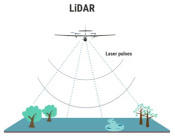
- PURPOSE: To collect aerial images and ground and riverbed elevation data along the Kiamichi River from Tuskahoma to Antlers. This helps us better understand the river’s shape, flow, and habitats and supports future water management planning.
- TIMING: Contractors completed the Aerial LiDAR and Imaging Survey in September 2025.
- PROCESS: Contractors flew a small, low-flying plane over the river to gather aerial photos and data using LiDAR (Light Detection and Ranging). LiDAR uses light pulses to measure ground and riverbed elevations. It’s safe for people and wildlife and commonly used for mapping.
- This information will be used to create an accurate 3D model of the river, including the riverbanks and bottom, vegetation, and other features in the river channel, including areas that support freshwater mussels. This model will help simulate how water flows in the Kiamichi River, including water released from Sardis Lake and future diversions near Moyers. These simulations will support decisions that protect both the water supply and the health of the river, in line with the Water Settlement Agreement.
- FINDINGS: The survey gathered a large amount of digital data. It will take several months to process and analyze it. Once complete, the data will guide future studies and help in building models of the river.
River Flow and Temperature Monitoring (Ongoing)
- PURPOSE: To collect more detailed information about water levels and temperatures along the Kiamichi River. This data will add to what the U.S. Geological Survey already measures at Big Cedar, Clayton, and Antlers.
- TIMING: Contractors installed monitoring stations at locations along the river in September 2025.
- FINDINGS: These stations regularly record the river’s water level and temperature. The information helps:
- Improve understanding of how water moves through the river.
- Support studies on habitat conditions for freshwater mussels.
- Track water temperatures during warmer months when river flows are lower.
River Sediment Studies and River Channel Conditions (Ongoing)
- PURPOSE: To characterize the sediment — the sand, silt, gravel, and rocks — that make up the Kiamichi River’s bottom and banks. This will help us understand how the river erodes, moves, and deposits sediment, and it will also help us address the stability of the river channel.
- TIMING: The first round of sediment sampling took place in October 2025. Additional samples will be collected later during higher river flows, when more sediment is moving through the river.
- FINDINGS: Oklahoma City will use these study results to help plan and design a low-profile riverbank water intake near Moyers, as designated by the Water Settlement Agreement and the Oklahoma Water Control Board water permit. These study results will also be important for the mussel studies to characterize their habitat requirements.
Mussel Bed Site Studies (Ongoing)
- PURPOSE: To study where freshwater mussels live along the Kiamichi River, how many there are, and how the river flows and water temperatures may affect them. This will include more detailed measurements in the river and may use aerial drone surveys in certain areas of the river.
- TIMING: The mussel bed site studies started in Fall 2025 and may continue into 2026.
- FINDINGS: Oklahoma City is coordinating these studies with the U.S. Fish and Wildlife Service, Oklahoma Department of Wildlife Conservation, Choctaw Nation, Chickasaw Nation, and independent mussel experts. The studies will be used in support of Oklahoma City’s Endangered Species Act consultation with the U.S. Fish and Wildlife Service. Federal and State permits were obtained to authorize the research including:
- Oklahoma Scientific Collector's Permit
- Recovery Permit issued by the U.S. Fish and Wildlife Service under Section 10(a)1(A) of the Endangered Species Act, Permit No. PER0009122
Pipeline Route Studies and Surveys
As part of the Kiamichi River Water Management Project (KRWMP), Oklahoma City is conducting several studies and surveys to protect natural and cultural resources while planning for the proposed water pipeline. Separate from the Kiamichi River field work, these efforts will not take place along the river and its corridor, with the exception of those needed specifically at the riverbank water intake location near Moyers.
Wetlands and Streams Studies
We’re identifying and mapping streams and wetlands, as well as studying the soils and plants in these areas. This helps us avoid or minimize any impacts to these sensitive environments during pipeline construction.
Before construction can begin, Oklahoma City must receive approval from the U.S. Army Corps of Engineers (Tulsa Regulatory Office) and a state Water Quality Certification. Our goal is to avoid streams and wetlands whenever possible. If temporary impacts can’t be avoided, we will minimize the affected area and restore it by reshaping, stabilizing, and reseeding the ground. Tunnels may be used under highways and larger streams when feasible, to avoid other disturbances.
Cultural and Historical Resource Surveys
Contractors are also surveying the pipeline route for historical, cultural, and archaeological resources. These surveys help ensure that we avoid or reduce any potential effects on these important sites. Oklahoma City is working with the U.S. Army Corps of Engineers, State Historic Preservation Office, the State Archeologist, and Tribal Historic Preservation Offices to complete and review these studies, following all state and federal requirements.
Wildlife and Endangered Species Studies
We are working closely with the U.S. Fish and Wildlife Service to identify and protect threatened and endangered species that may live near the project area. Special studies will focus on federally listed freshwater mussels in the Kiamichi River to help ensure their protection.
Geotechnical Studies
Geotechnical work is also underway to study the soil, rock, and groundwater conditions along the proposed pipeline route. To perform this work, small holes are drilled using a rig to collect samples and better understand underground conditions, which helps guide safe and effective pipeline design and construction. After drilling, each site is backfilled, smoothed, and restored according to Oklahoma Water Resources Board standards.
Frequently Asked Questions
Why is Oklahoma City conducting field studies on the Kiamichi River?
The studies are required by the 2016 Water Settlement Agreement – a historic agreement between the Choctaw Nation of Oklahoma, Chickasaw Nation, United States, State of Oklahoma, and The City of Oklahoma City. Approved by Congress and signed into Federal law, the Settlement Agreement establishes the framework governing how water resources in the Kiamichi River basin must be managed. The environmental studies will provide important information needed for permits, water management, and conservation efforts. Over time, this data will also help support community watershed management.
When and how can I see the results of the field studies?
Oklahoma City contractors are completing the studies in coordination with federal and state agencies, including the U.S. Army Corps of Engineers, U.S. Fish and Wildlife Service, Tribal Nations, and independent mussel specialists.
The results will be shared with the following agencies to support required environmental reviews and permits:
- The U.S. Army Corps of Engineers in support of Clean Water Act Section 404 permitting
- The U.S. Fish and Wildlife Service for Endangered Species Act consultation
- The State Historic Preservation Office, State Archaeologist, and Tribal Historic Preservation Offices in compliance with Section 106 of the National Historic Preservation Act
Once submitted, the reports will become public record with the U.S. Army Corps of Engineers, U.S. Fish and Wildlife Service, and State Historic Preservation Office. There will be public notice when Oklahoma City’s Clean Water Act Section 404 permit application is submitted to the U.S. Army Corps of Engineers.
Oklahoma City will also continue to share project and study updates on this website as work progresses.
How can I get more information about what studies are planned for or currently taking place in my area?
Contact Jessi Early at (405) 212-9110 or jessi.early@srbok.com.
Is this part of the Southeast Oklahoma Power Corporation’s (SEOPC) proposed pumped-storage hydroelectric power project?
No. Any work related to the KRWMP is in no way connected to the Southeast Oklahoma Power Corporation’s proposed hydroelectric project, an out-of-state private development that is opposed by the City. The City of Oklahoma City joined with the Choctaw and Chickasaw Nations as well as the State of Oklahoma to oppose the SEOPC project and the past Tomlin Energy project.